17 December 2015
by Francesco Zoppi
16 December 2015
by Francesco Zoppi
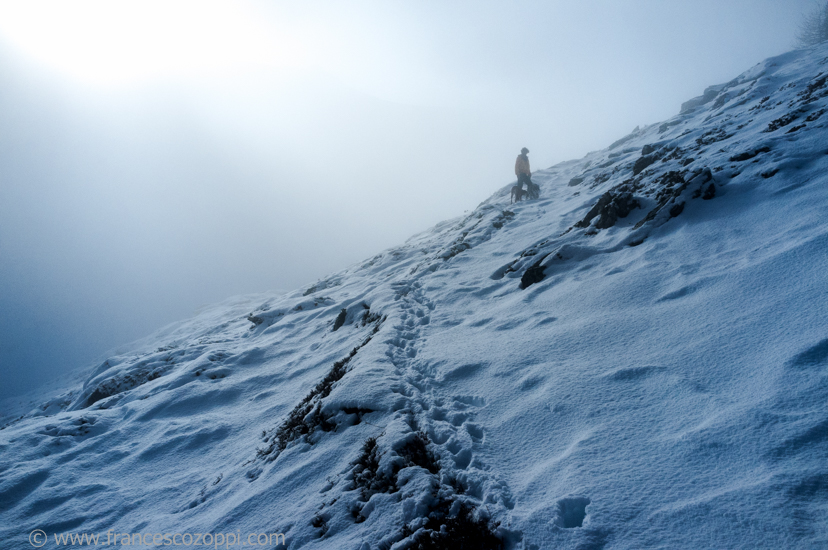
The way to the summit
The way to the summit is a picture taken in Valle d’Aosta
The Aosta Valley is a mountainous semi-autonomous region in northwestern Italy. It is bordered by Rhône-Alpes, France to the west, Valais, Switzerland to the north and the region of Piedmont to the south and east.
Covering an area of 3,263 km2 (1,260 sq mi) and with a population of about 128,000 it is the smallest, least populous, and least densely populated region of Italy. It is the only Italian region that has no provinces (the province of Aosta was dissolved in 1945).[6] Provincial administrative functions are provided by the regional government. The region is divided into 74 comuni (communes).
Italian and French are the official languages,[1] though much of the native population also speak Valdôtain, a dialect of Arpitan, as their home language; about half of the population can speak all three languages.[7]
The regional capital is Aosta.
The Dora Baltea Valley, between 300 and 1000 metres above sea level, has the mildest climate in the Region, with a typical Oceanic climate (Cfb). The winters are mild, even milder than the Po Valley, but are usually wet and foggy. Snow is frequent only during January and February, but the foggy season, which starts in late October, lasts until May. The temperature average for January is between −1 °C (30 °F) and 3 °C (37 °F). The summers are mild and usually rainy. Temperature averages in July are between 17 °C (63 °F) and 20 °C (68 °F). The main towns in this area are Aosta, Saint-Vincent, Châtillon and Sarre. Due to the occidental position at the Alpine Arc, the climate classified as Cfb may extend to relatively high places, especially near the French border, which receives mild oceanic wind, so it’s possible to find locations at 1500, or even 1900 metres high with the same Cfb climate, but the temperatures are lower, around −2 °C (28 °F) in the winter and 15 °C (59 °F) in the summer, with mist throughout the year.
15 December 2015
by Francesco Zoppi
14 December 2015
by Francesco Zoppi
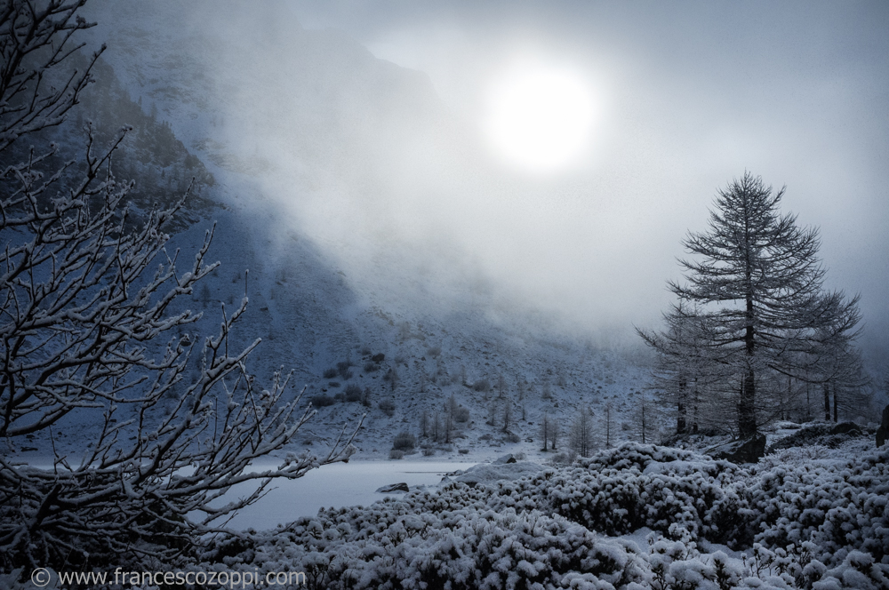
Frozen Forest
Frozen Forest in the place named Aosta Valley is a mountainous semi-autonomous region in northwestern Italy. It is bordered by Rhône-Alpes, France to the west, Valais, Switzerland to the north and the region of Piedmont to the south and east.
Covering an area of 3,263 km2 (1,260 sq mi) and with a population of about 128,000 it is the smallest, least populous, and least densely populated region of Italy. It is the only Italian region that has no provinces (the province of Aosta was dissolved in 1945).[6] Provincial administrative functions are provided by the regional government. The region is divided into 74 comuni (communes).
Italian and French are the official languages, though much of the native population also speak Valdôtain, a dialect of Arpitan, as their home language; about half of the population can speak all three languages.
The region is very cold in the winter, especially when compared with other places in the Western Alps. This is probably due to the mountains blocking the mild winds from the Atlantic Ocean. Places on the same altitude in France or western Switzerland are not as cold as the Aosta Valley.
The Aosta Valley may be divided into different climatic zones:
The Dora Baltea Valley, between 300 and 1000 metres above sea level, has the mildest climate in the Region, with a typical Oceanic climate (Cfb). The winters are mild, even milder than the Po Valley, but are usually wet and foggy. Snow is frequent only during January and February, but the foggy season, which starts in late October, lasts until May. The temperature average for January is between −1 °C (30 °F) and 3 °C (37 °F). The summers are mild and usually rainy. Temperature averages in July are between 17 °C (63 °F) and 20 °C (68 °F). The main towns in this area are Aosta, Saint-Vincent, Châtillon and Sarre. Due to the occidental position at the Alpine Arc, the climate classified as Cfb may extend to relatively high places, especially near the French border, which receives mild oceanic wind, so it’s possible to find locations at 1500, or even 1900 metres high with the same Cfb climate, but the temperatures are lower, around −2 °C (28 °F) in the winter and 15 °C (59 °F) in the summer, with mist throughout the year.
26 November 2015
by Francesco Zoppi
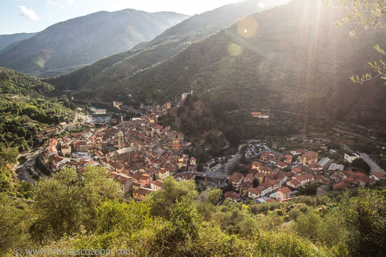
Badalucco
Badalucco is a comune (municipality) in the Province of Imperia in the Italian region Liguria, located about 100 kilometres (62 mi) southwest of Genoa and about 15 kilometres (9 mi) west of Imperia. As of 31 December 2004, it had a population of 1,254 and an area of 15.8 square kilometres (6.1 sq mi).[1]
Imperia is well known for the cultivation of flowers and olives, and is a popular summer destination for visitors. The local Piscina Felice Cascione indoor pool has hosted numerous national and international aquatics events. The economy of Imperia is based on tourism, food industry (olive oil and pasta), a specialized agriculture (olive groves and flowers in greenhouses) and on trading and harbour activities. The seaside tourism represents an important aspect of the economy of Imperia.
Badalucco borders the following municipalities: Bajardo, Ceriana, Dolcedo, Molini di Triora, Montalto Ligure, and Taggia.
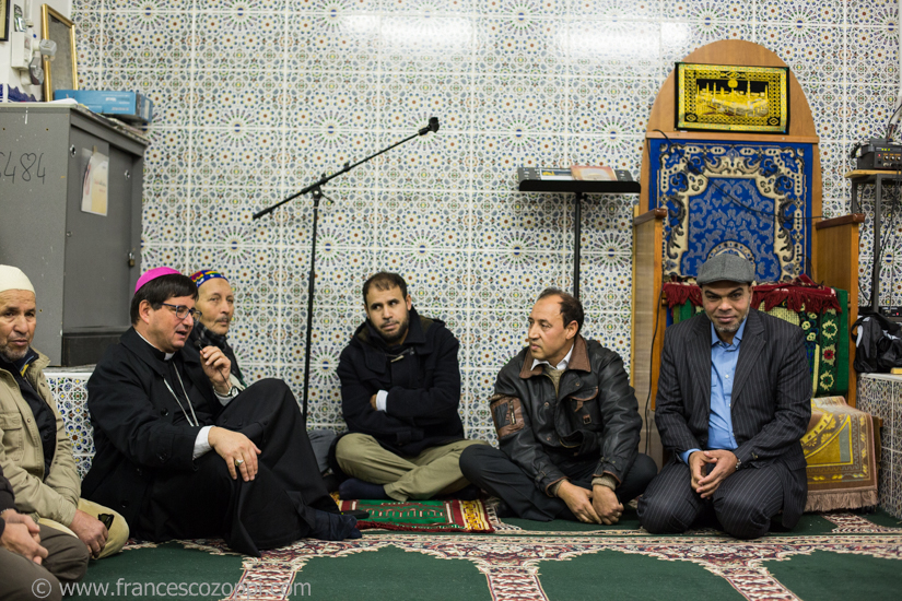
The meaning of Upstream Cods is to follow the full production chain backwards: we’ll start from Liguria’s festivals and restaurants concerned stockfish and salted cod, going upstream to the Lofoten islands, Norway, where the cods are fished and prepared to be sold to public, as we know it…be sure that we are also going to snoop around on how they are cooked in their native land. And, by the way, we will photograph the natural beauty of these remote islands located beyond the Arctic Circle! So, if you’d like to follow us in this adventure, and you want to follow Upstream Cods project plaese, like and share this page https://www.facebook.com/UpstreamCods
Some pictures are visible here
17 November 2015
by Francesco Zoppi
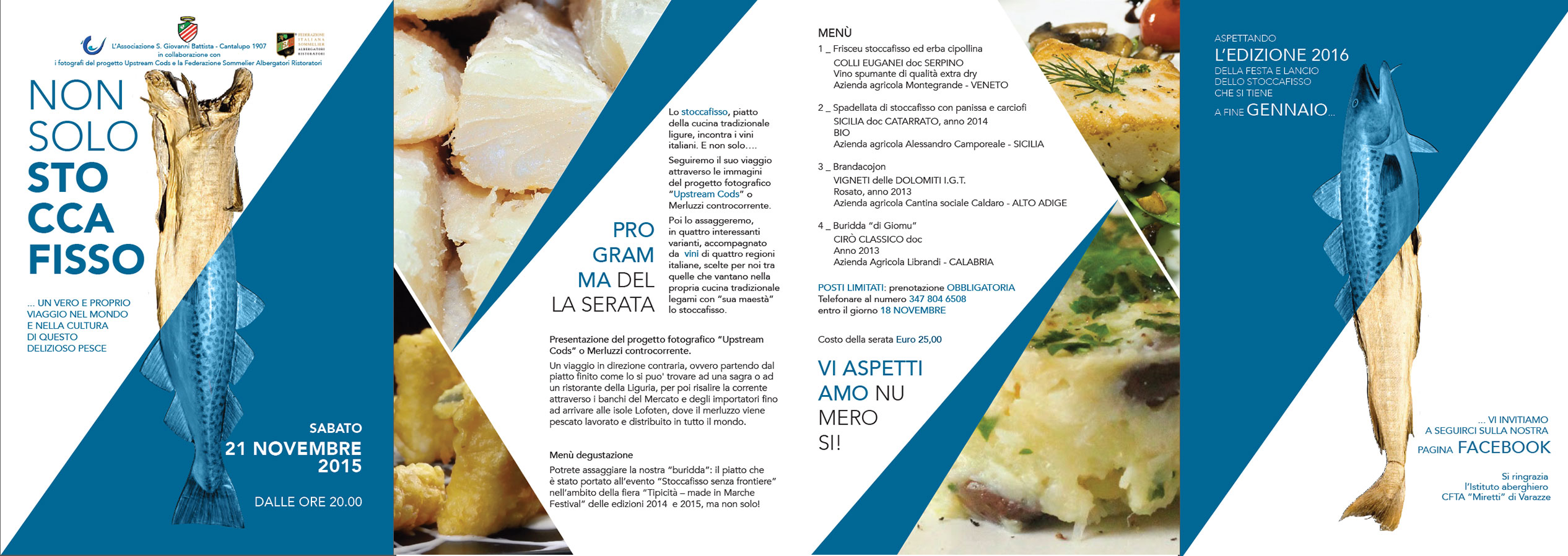
Upstream Cods will be at “Non solo stoccafisso” with an exhibit of our project.
Upstream cods is our way to tell people the story, using pictures, about stockfish and salted cod, how these two products gets fished, prepared and presented to everyone’s table.
The meaning of Upstream Cods is to follow the full production chain backwards: we’ll start from Liguria’s festivals and restaurants concerned stockfish and salted cod, going upstream to the Lofoten islands, Norway, where the cods are fished and prepared to be sold to public, as we know it…be sure that we are also going to snoop around on how they are cooked in their native land. And, by the way, we will photograph the natural beauty of these remote islands located beyond the Arctic Circle! So, if you’d like to follow us in this adventure, and you want to follow Upstream Cods project plaese, like and share this page https://www.facebook.com/UpstreamCods
15 November 2015
by Francesco Zoppi
Imperia is a coastal city and comune in the region of Liguria, Italy. It is the capital of the province of Imperia, and historically it was capital of the Intemelia district of Liguria. Mussolini created the city of Imperia on 21 October 1923 by combining Porto Maurizio and Oneglia and the surrounding village communes of Piani, Caramagna Ligure, Castelvecchio di Santa Maria Maggiore, Borgo Sant’Agata, Costa d’Oneglia, Poggi, Torrazza, Moltedo and Montegrazie.
Imperia is well known for the cultivation of flowers and olives, and is a popular summer destination for visitors. The local Piscina Felice Cascione indoor pool has hosted numerous national and international aquatics events.(wikipedia)
The meaning of Upstream Cods is to follow the full production chain backwards: we’ll start from Liguria’s festivals and restaurants concerned stockfish and salted cod, going upstream to the Lofoten islands, Norway, where the cods are fished and prepared to be sold to public, as we know it…be sure that we are also going to snoop around on how they are cooked in their native land. And, by the way, we will photograph the natural beauty of these remote islands located beyond the Arctic Circle! So, if you’d like to follow us in this adventure, and you want to follow Upstream Cods project plaese, like and share this page https://www.facebook.com/UpstreamCods
Some pictures are visible here
11 November 2015
by Francesco Zoppi
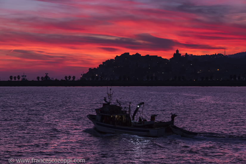
Genova is the capital of Liguria and the sixth largest city in Italy with a population of 592,995[1] within its administrative limits on a land area of 243.6 km2 (94 sq mi). The urban area called Genoa Metropolitan City has an official population of 862,885.[2] Over 1.5 million[2] people live in the Genoa Metropolitan Area. Genoa is one of Europe’s largest cities on the Mediterranean Sea and the largest seaport in Italy.
Genoa has been nicknamed la Superba (“the Proud one”) due to its glorious past and impressive landmarks.[3] Part of the old town of Genoa was inscribed on the World Heritage List (UNESCO) in 2006 (see below). The city’s rich cultural history in notably its art, music and cuisine allowed it to become the 2004 European Capital of Culture. It is the birthplace of Christopher Columbus and Niccolo Paganini.
In the picture Genova Sturla from the series “Under a cloudy sky”
9 November 2015
by Francesco Zoppi
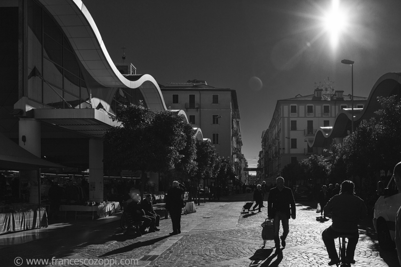
Upstream cods team visits a market in la Spezia. At the head of the Gulf of La Spezia in the Liguria region of northern Italy, is the capital city of the province of La Spezia. In terms of population, La Spezia is the second city in the Liguria region, preceded just by Genoa. Located between Genoa and Pisa on the Ligurian Sea, it is one of the main Italian military and commercial harbours and hosts the arsenal of the Italian Navy. It is important for its museums, for the Palio del Golfo, and for the railway and boat links with Cinque Terre.
The meaning of Upstream Cods is to follow the full production chain backwards: we’ll start from Liguria’s festivals and restaurants concerned stockfish and salted cod, going upstream to the Lofoten islands, Norway, where the cods are fished and prepared to be sold to public, as we know it…be sure that we are also going to snoop around on how they are cooked in their native land. And, by the way, we will photograph the natural beauty of these remote islands located beyond the Arctic Circle! So, if you’d like to follow us in this adventure, and you want to follow Upstream Cods project plaese, like and share this page https://www.facebook.com/UpstreamCods
Some pictures are visible here
7 November 2015
by Francesco Zoppi

Manarola is a beautiful colored town part of Cinque Terre in Liguria.
Besides enjoying the beauty of this small town, hiking the trails to the other towns is definitely worth a day or two in the area. See Cinque Terre for more information on the paths.When you arrive at the train station, you may need to go underground to reach the main platform. Head down the tunnel toward the city. During World War 2, the residents spent the nights here for protection. There is a wonderful art gallery with oil paintings and watercolors of the cinque terre towns. Turn right and up the hill — this road used to be a stream, with bridges crossing , similar to Venice. The stream was paved over and you can still hear the running water. About half way up, there is still an old water wheel. At the top is the church of S.Lorenzo.
To get to the via dell amore, go back through the tunnel towards the train station. Around the back are steps leading up to the trail. Be sure to have your ticket (available at the cinque terre office near the train station. )
The meaning of Upstream Cods is to follow the full production chain backwards: we’ll start from Liguria’s festivals and restaurants concerned stockfish and salted cod, going upstream to the Lofoten islands, Norway, where the cods are fished and prepared to be sold to public, as we know it…be sure that we are also going to snoop around on how they are cooked in their native land. And, by the way, we will photograph the natural beauty of these remote islands located beyond the Arctic Circle! So, if you’d like to follow us in this adventure, and you want to follow Upstream Cods project plaese, like and share this page https://www.facebook.com/UpstreamCods
Some pictures are visible here